File:Carte brésil.png
From Wikimini Stock
Size of this preview: 206 × 240 pixels. Other resolution: 516 × 600 pixels.
Original file (516 × 600 pixels, file size: 219 KB, MIME type: image/png)
Summary
| Description |
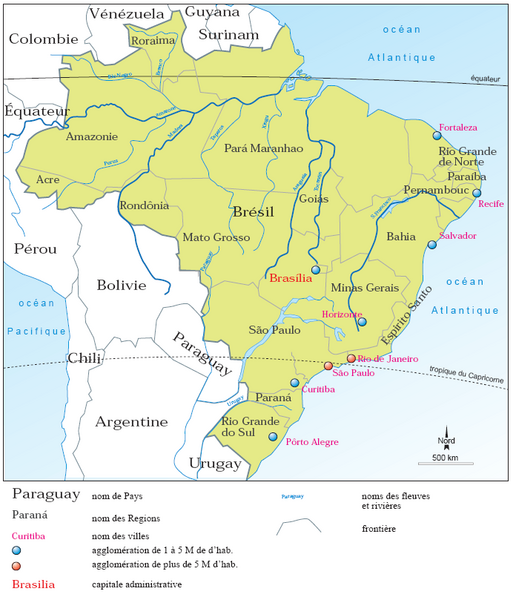
Français : Carte du Brésil (géographie politique) avec ses pays limitrophes.
|
| Source | https://commons.wikimedia.org/wiki/File:Br%C3%A9sil.png |
| Author | Vacnor |
Licensing
| |
The person who uploaded this file (see below) certifies that he/she has verified the legal terms of use of this image/photo (coypright status) before adding it to Wikimini.
Specifically, use of this image/photo is permitted because it was published under the following free license:
|
File history
Click on a date/time to view the file as it appeared at that time.
| Date/Time | Thumbnail | Dimensions | User | Comment | |
|---|---|---|---|---|---|
| current | 18:36, 9 November 2025 | | 516 × 600 (219 KB) | Simon Tournier (talk | contribs) | {{Information |Description = {{fr| Carte du Brésil (géographie politique) avec ses pays limitrophes. }} |Source = https://commons.wikimedia.org/wiki/File:Br%C3%A9sil.png |Author = Vacnor }} {{PAGENAME}} |
- You cannot overwrite this file.
File usage
There are no pages on the Stock that use this file.
Check on:
- Encyclopedias
- Wikimini ES (Wikimini en español)
- Wikimini FR (Wikimini en français)
- Wikimini SV (Wikimini på svenska)
- Other