File:Canada-Carte administrative.png
From Wikimini Stock

Size of this preview: 272 × 240 pixels. Other resolutions: 681 × 600 pixels | 1,280 × 1,128 pixels.
Original file (1,280 × 1,128 pixels, file size: 522 KB, MIME type: image/png)
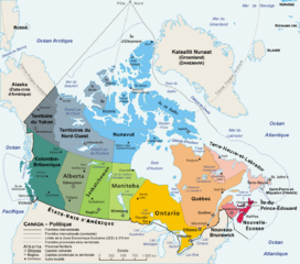
Carte géopolitique du Canada illustrant les 13 subdivisions de premier rang.
Cette image provient de Wikimedia Commons.
File history
Click on a date/time to view the file as it appeared at that time.
| Date/Time | Thumbnail | Dimensions | User | Comment | |
|---|---|---|---|---|---|
| current | 01:34, 20 February 2009 | | 1,280 × 1,128 (522 KB) | Lorangeo (talk | contribs) | Carte géopolitique du Canada illustrant les 13 subdivisions de premier rang. Cette image provient de [http://commons.wikimedia.org/wiki/Image:Carte_administrative_du_Canada.png?uselang=fr Wikimedia Commons]. |
- You cannot overwrite this file.
File usage
There are no pages on the Stock that use this file.
Check on:
- Encyclopedias
- Wikimini ES (Wikimini en español)
- Wikimini FR (Wikimini en français)
- Wikimini SV (Wikimini på svenska)
- Other